

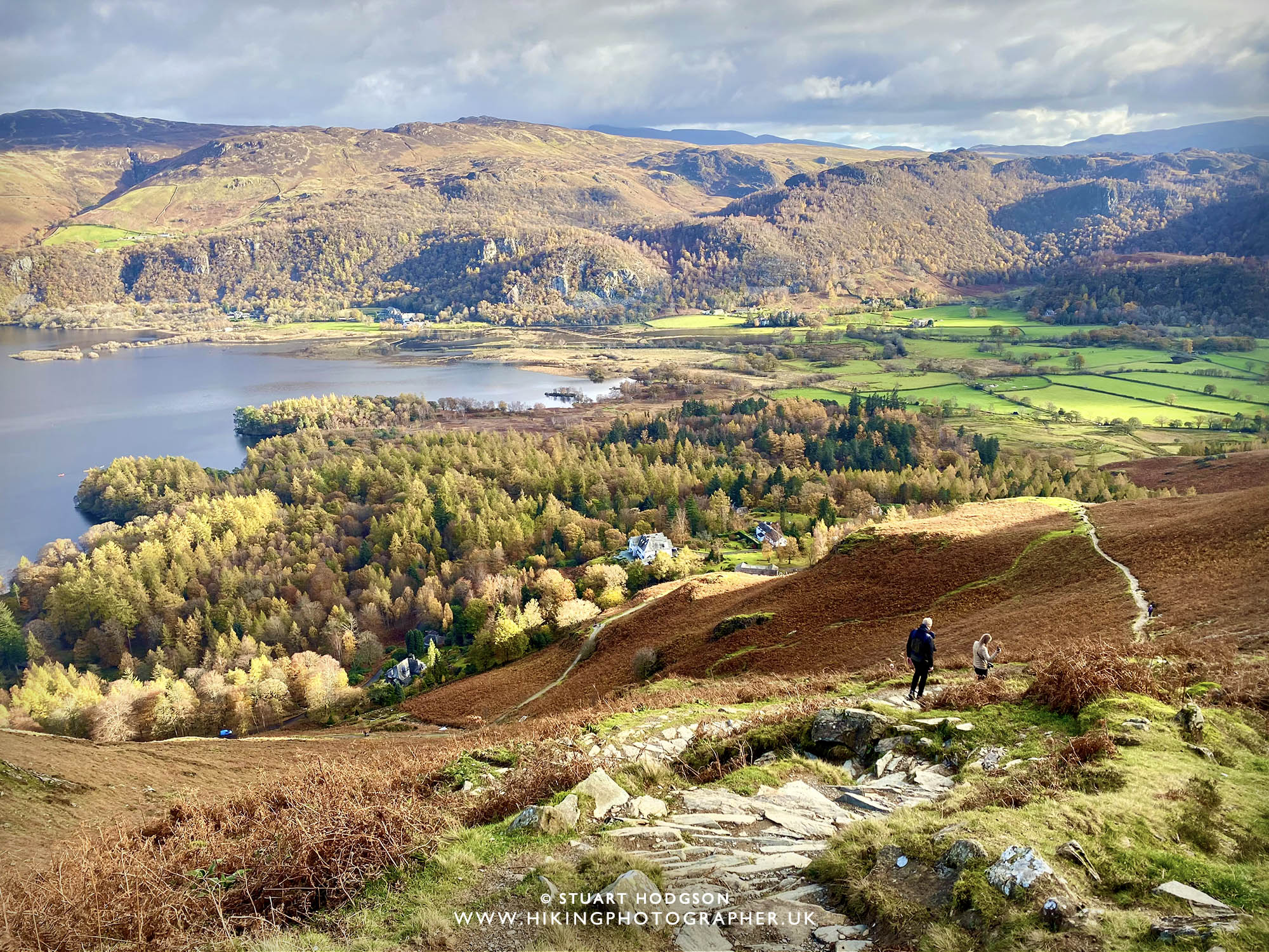
The summit of Catbells (left of centre of the photo) overlooking Derwent Water, near Keswick in the English Lake District. Cat Bells is one of the most popular walks in the Lakes and for good reason. For any visitors in the Lake District looking for walks for all ages near Keswick – it’s a must-do walk, that feels like a mini mountain with a bit of everything and there are 4 classic routes you can do that are featured on this blog post further below.
Catbells – one of the Lake District’s most popular WALKS & for good reason
When thinking of the most popular walks and iconic fells in the Lake District, those that come to mind are the high summits of Helvellyn, The Old Man of Coniston and Scafell Pike. I’d also add Catbells to this iconic list, yet it’s much smaller in height and a very manageable walk so perfect for those first time Lake District visitors and those new to walking or with kids.
Life Insuranc
 |
| Read on to find out all the answers to Frequently Asked Questions about Catbells |
CATBELLS – FREQUENTLY ASKED QUESTIONS:
HOW LONG DOES IT TAKE TO WALK UP CATBELLS?
The walk up to the Catbells summit, if you park at the closest point, is about 30 to 40mins and most people walk up form the northern end which is the steepest way as shown on the route maps in this blog post. I also highly recommend walking up the steeper northern end first and coming down the gentler southern side.
HOW LONG DOES IT TAKE TO WALK UP AND DOWN CATBELLS?
This depends on the route you take as there are a few options of varying length as shown on this blog post. The quickest route up and down the shortest distance can be done in an hour but that would be rushing it. I recommend allocating more time and doing one of the circular routes featured on this blog post, depending on how much time you have.
HOW HIGH IS CATBELLS?
Catbells is 451m (1,480ft) and it’s distinctive shape make it a well-known landmark with impressive views of Derwent Water, Keswick and the surrounding mountains, like Skiddaw on clear days.
HOW HARD IS IT TO CLIMB CATBELLS?
I would class this as a moderate walk, whilst short in distance and quick to do, it is steep in 2 short sections (if done head-on from the northern end via Skelgil Bank) and there are some little scrambles that may require you to use your hands, which isn’t difficult at all in dry conditions, but those less mobile, new to fell-walking and who are a bit scared of heights may not feel comfortable in some of these more exposed positions. It’s all perfectly safe in good conditions though if you take your time and it does make the walk a little bit more fun and varied and kids will love it.
WHY IS CATBELLS CALLED 'CATBELLS'?
It’s unclear why the name is Catbells but it’s probably a corruption of an old english term in reference to where wild cats still roamed the area. Rest-assured they don’t now 🙂
WHERE IS CATBELLS?
Catbells is a popular walk near Keswick in the English Lake District, Cumbria. It overlooks Derwent Water lake and has superb views for it’s relatively modest height compared to the bigger Lake District Mountains. If you are on holiday in the Keswick area and staying in a cottage or Bed & Breakfast then put this walk on your list 😉
Be prepared for your Catbells walk
Some may say it’s an easy walk in the context of all the Lake District mountains if you are an experienced walker, but usually those who tackle Catbells are first-timers to the Lakes so be prepared. Wear suitable walking footwear with good grip (especially in the wet) and take an extra layer or two for the summit top (it always gets a bit chillier on summits once you stop for a rest) Check the weather forecast (it can change quickly in the Lakes) and take a drink and a snack (to enjoy the summit views even more).
It’s well worth getting a Phone Map App on your phone to download map routes to make sure you keep on the right path – I recommend the one by Ordnance Survey and you’ll find details on this further down the page.
PRESERVE BEAUTY SPOTS, LEAVE NO TRACE & DO OUR BIT
More people enjoying natural beauty spots and connecting with nature is good thing, but a small minority are leaving rubbish or causing damage, giving everyone else a bad name. I’m not into gatekeeping these places—plenty of people share them—but let’s do it responsibly. Please don’t leave rubbish, be considerate of others, and if you spot any litter and can take it with you, you’re a legend. No one gets paid to clean these places, so every small act helps protect their beauty. And if you share your adventures online, use your influence to encourage respect, leave no trace, take only memories and enjoy the outdoors responsibly. Cheers!
 |
|
Here are the 4 best Catbells Walking Routes in my humble opinion:
|
The 4 best and most popular walking routes to Catbells and back
Often those who walk to the summit of Catbells are relatively new to walking – so I thought I would share some of my favourite and best routes to Catbells. The routes are of varying distance and starting points – and which route you choose all depends on the time you have available really and your modes of transport. In all the routes I highly recommend heading up the steepest section first to Catbells via Skelgil Bank, and coming down the southern end. It can be a bit tricky coming down the steepest end.
In terms of getting to the start of these walks, the first 3 walks start at the foot of Skelgil Bank – where you can park the car (see details at the end of this blog post). However parking is limited. You may wish to get the ferry over to Kitchen Bay which is near the start of these walks. The last route featured on this page you actually start the walk from Keswick itself!
#1. My FAVOURITE SHORT CATBELLS WALK
Catbells circular walking route (with stunning views of Derwent Water)
#1 WALK OVERVIEW:
WALK DISTANCE: 3.7 miles
WALK TIME: 2 hours
WALK DIFFICULTY: MODERATE

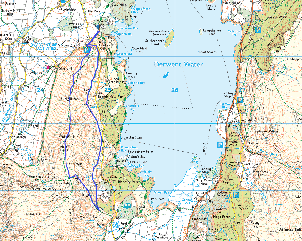 |
| This route starts from the foot of Skelgil Bank and goes in an anti-clockwise direction. If you get here early in the car you should be able to find a parking spot – but there aren’t lots of spaces (see further down the blog post for more details on parking at Catbells). My top tip is to go in this direction, tackling Skelgil Bank on the ascent as it’s steeper (you might need to use your hands on a few short sections) and it means you’ll have a gentler descent. I like to think of Catbells as a mini-mountain, as whilst it’s a relative short walk and modest height – it has a bit of everything! Once you have descended Catbelsl the return leg takes you along the eastern edge of Catbells to give stunning views of Derwent Water along every step of the way. |
 |
|
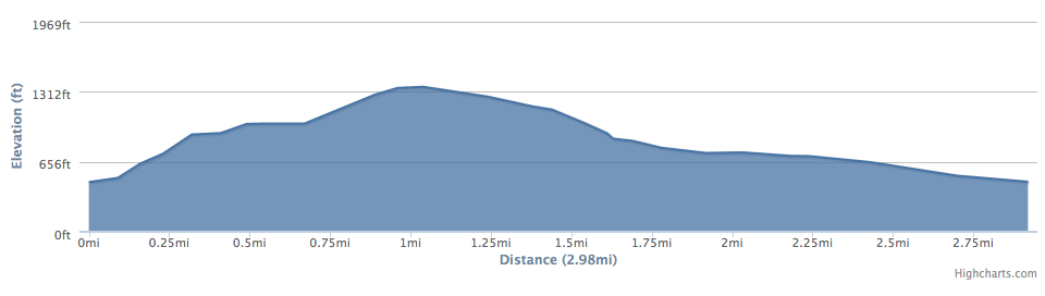
As you can see on this elevation chart for this route – once Catbells has been tackled it’s plain sailing on the way back
|
 |
|
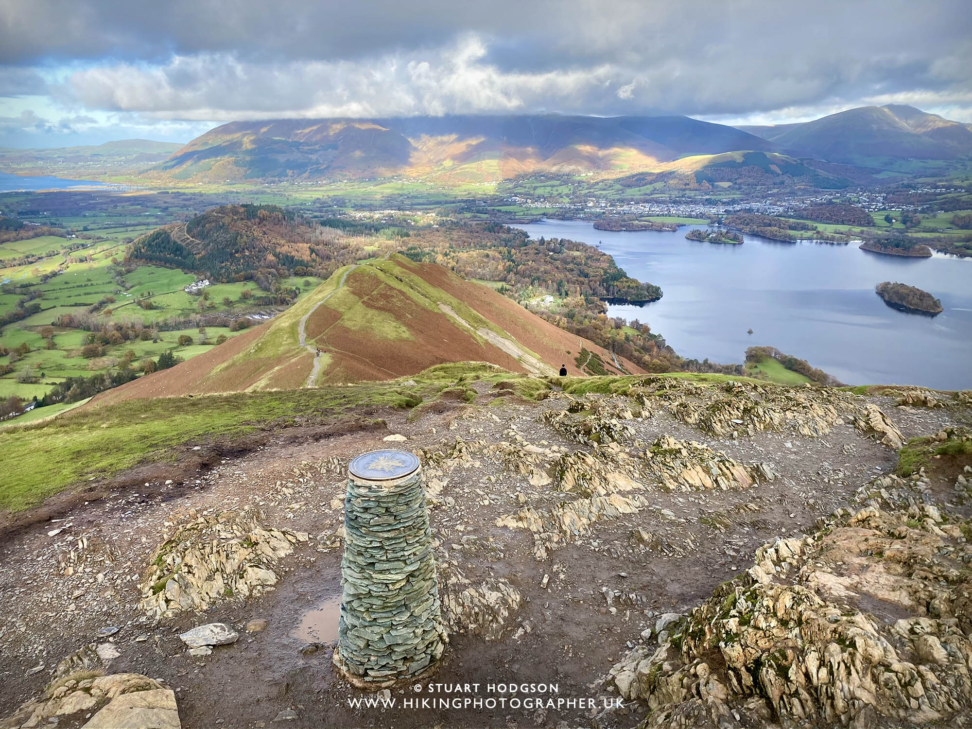
On this photo I have illustrated the path you will take on the Catbells route above so you can get a feel for the kind of terrain you will be walking. You can see the initial steep zig zag route up Skelgil Bank. The route isn’t that technical and can be done by kids who have a sense of adventure, however Skelgil Bank is steep in 2 short sections and there are 2 little scrambles up rock that will probably require you to use your hands, and those new to walking who are a bit scared of heights may not feel comfortable in some of these more exposed positions. If you click the banner link below it will take you to a dedicated blog post on this particular route with lots more photos of what to expect on this specific walking route. |
WALKS YOU MIGHT LIKE
#2. The quickest cat bells route
The shortest circular Catbells walk route (with views of Newlands Valley)
This route is the quickest circular walk which returns via the western edge of Cat Bells over looking Newlands Valley (It’s not as quick as a straight ‘up & down the way you came’ but circular routes are just better and more interesting aren’t they! This ascent is the same as the route above, but on the return leg you are in the newlands valley so won’t get the Derwent Water views.
#2 WALK OVERVIEW:
WALK DISTANCE: 3 miles
WALK TIME: 1.5 hours
WALK DIFFICULTY: MODERATE
 |
| This is the quickest route to the top of Catbells and back. It starts at the Car Park at the foot of Skelgil Bank, and then it’s straight up Skelgil bank – onto the summit of Catbells and the down the western edge of Catbells via Brunt Crag then onto Skelgil. This gives good views of the Newlands Valley. |
 |
| The view from the summit of Catbells is pretty impressive and you’ll get stunning views of Derwent Water, Keswick and in the distance you can see the mountains of Skiddaw & Blencathra shrouded in cloud. |
#3. CATBELLS WALK VIA SHORES OF DERWENT WATER
A longer Catbells walk, returning via the Cumbrian Way & Derwent Water
WALK OVERVIEW:
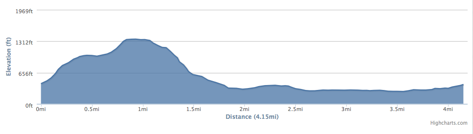
WALK DISTANCE: 4.2 miles
WALK TIME: 3 hours
WALK DIFFICULTY: MODERATE
 This is an excellent way of walking Catbells as it gives a lot of variety and different views. As well as the great views from Catbells, you complete your return walk through the woodland of Manesty Park and along the Cumbrain Way along Derwent Water’s edge around Brandelhow Bay and onto Brandelhow Park. You can start this route in multiple locations, either from the Skelgil Car Park or any of the 3 Ferry landing stages along the route.
|
||
| The descent from Catbells via the southern end is much gentler and you will see some stunning views of Borrowdale, Manesty Forest and over to Walla crag and the Ashness Bridge area. On this photo Manesty Park is in full view and on the longer walk you can walk through the forest to vary the walk up. |
#4. Catbells walk from Keswick
The longest route without the hassle of parking
If you’ve got time on your hand’s and don’t want to travel in the car (and avoid the hunt for a rare car park space) – then why not walk from Keswick! It’s obviously longer, and comes in at about 4+ hours – but it’s a nice walking route to do.
#4. WALK OVERVIEW:
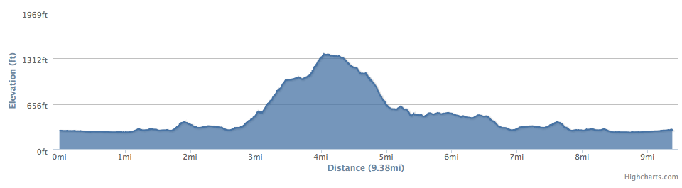
WALK DISTANCE: 9.4 miles
WALK TIME: 4 hours
WALK DIFFICULTY: HARD
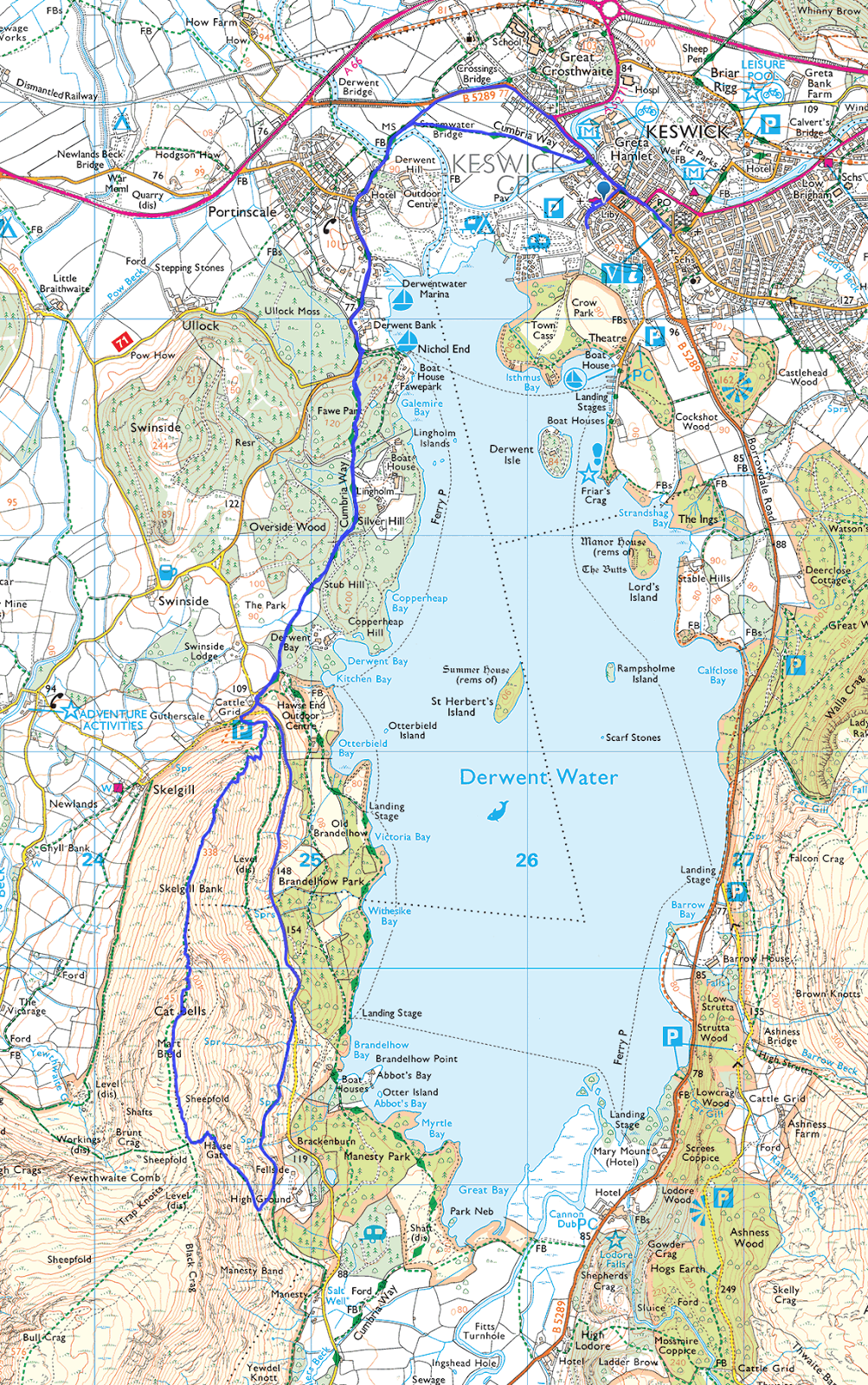 |
| This route is ideal if you want to start from Keswick and fancy a longer walk or don’t want to travel via car/ferry/bus to the usual starting points nearer Catbells. The walk begins along the Cumbrian Way out of Keswick and heads to Portinscale and Fawe Park and then you walk up to Catbells via Skelgil bank in much the same way as the routes above. You would then return along the easter edge of Catbells then onto the same way back to Keswick via The Cumbrian way – or you could even catch the ferry back at the landing stage at Hawes End if you time it right! |
 |
| When walking to Cat bells from Keswick you have plenty of time to warm up before you begin the ascent of Cat Bells – with a leisurely stroll back to Keswick |
 |
| The summit of Catbells overlooking Derwent Water near Keswick. In terms of accessibility – Catbells is one of the most popular and best walks in the Lake District. For any new visitors to Keswick in the Lakes – it’s a must do walk |
Extending your Catbells walk to MORE Lakeland Fells
WHere to park for a Catbells Walk?
Whilst free to park, there isn’t great deal of car parking spaces at the very foot of Skelgil Bank (maybe room for 10 cars or so) which get full quite easily. If this is the case, head along the road to Grange on the eastern edge of Catbells where there are sections where you can park on the roadside (see photo below), again not massive amounts of car park spaces, so on a weekend with good weather it may prove tricky to find a spot. Tip – get there early, do the walk out of season or do it midweek, or get the boat from Keswick! Wherever you do park, please park responsibly, don’t block entrances and keep in mind to leave enough room to allow emergency vehicles to get past if they need too!
 |
| You can just about make out the road along the eastern edge of Catbells here (left of the photo) which leads to Grange, and you can see the tiny cars parked on the road side. This is your best chance of finding somewhere to park (and its free). |
HISTORY OF CATBELLS IN THE LAKE DISTRICT
The history of Catbells in the Lake District dates back to the last Ice Age, when the region’s glacial activity helped shape the distinctive landscape we see today. The mountain is a result of volcanic activity that occurred millions of years ago, forming the rocky outcrops and gentle ridges that characterize Catbells. Its location on the eastern shore of Derwentwater places it at a crucial point in the geological history of the Lake District, with the surrounding valley being carved by glaciers during the last ice sheet’s retreat.
In more recent history, Catbells has had a significant role in the cultural landscape of the Lake District. The mountain was likely an important landmark for early inhabitants of the area, who would have used it as a navigation point. The surrounding area also boasts a rich history of settlement, with evidence of farming communities dating back to ancient times. Catbells, along with other peaks in the region, would have formed a part of the local people’s landscape, influencing their daily lives and activities.
Catbells has also been an integral part of the artistic and literary heritage of the Lake District. Famous figures such as William Wordsworth, who spent much of his life in the region, were inspired by the natural beauty of the landscape. Artists and poets have long sought inspiration from the views and surroundings of Catbells, capturing the mountain’s presence in their works. Over time, the peak has become more than just a geographical feature; it has grown into a symbol of the enduring beauty and spirit of the Lake District, cherished for its history and cultural significance.
CATBELLS – A MUST-DO LAKE DISTRICT WALK NEAR KESWICK
I hope this little blog post sheds some light on walking up Catbells and for those unfamiliar with the the Lake District it helps you plan your walk! It’s one of my most popular blog posts that has helped thousands plan a visit to Catbells. Because of the blog post popularity – please respect the area when visiting and don’t leave your litter to spoil it for others. Please also be considerate to others when parking. I do though highly recommend Catbells if you are in the Keswick area as it offers some stunning Lake District views. Enjoy our visit!


Top 10 LAKE DISTRICT Wild Swimming spots: digital guide
In this unique guide, you’ll discover my 10 best wild swimming locations in the Lake District. From hidden emerald plunge pools & secret waterfalls to serene mountain tarns. The guide takes away the guesswork and gives you everything you need to easily and quickly find these breathtaking spots:
- Precise what3words locations (down to 3 metres)
- Clear walking routes, with maps + GPX files
- Free parking tips to avoid unnecessary costs
- A phone-friendly, downloadable on-the-go format with clickable links and offline access
If you want less searching and more swimming — this is the wild swimming guide for you


We did No1 with a 6 and 2 year’s old. We were very glad to follow you r tip for a scramble ascent and “boring” descent. My 6 year old love d it
Glad you found the blog post useful and enjoyed the walk to Catbells – it’s definitely best going up the steeper way via Skelgil Bank and back down the gentler way